Coverage Predictions
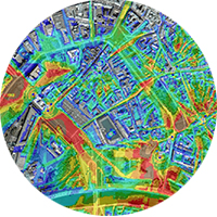
 The Radio Frequency (RF) Coverage Predictions generated by CartGIS combine the complex RF propagation tools with spatial data. The analysis is available for a single radio communication site or total network coverage. The process creates a terrain grid based on digital elevation data and determines the path loss in all directions from the transmitter.
A range of input parameters is applied to the industry standard propagation algorithms to predict the field strength or propagation loss. Various propagation models are available and the output options include Field Strength Contour, Best Server Field Strength, Best Server Transmitter, and Number of Serving Transmitters. The format is optimised with the client to provide valuable network information.
The presentation is adjusted to suit client requirements. The full colour coverage prediction is normally overlayed onto a map and combined with the relevant geographic data. The field strength contours (e.g. 2uV & 10uV) are also adjustable to suit individual network requirements. The analysis is normally presented in A3 colour, or an electronic format suitable to email.
They are available in a variety of formats ranging from vector & raster and all common GIS formats including ArcGIS and Google Earth.
CartGIS uses high end industry radio modeling software. We DO NOT USE freeware radio coverage software or online generators. It is important that your outcome is reliable and correct. We also use high resolution digital elevation models and accurate terrain and ground cover data.
Path Predictions
The RF Path Profile provides a propagation analysis between two radio communication sites. It uses digital elevation data and link parameters to determine the impact of the intervening terrain on the line of site path. The first Fresnel zone clearance is also considered. Variables such as antenna height, antenna characteristics, transmitter power, system losses and receiver sensitivity are adjusted to suit client requirements.
Various internationally recognised propagation models (e.g. Longley-Rice, Okumura-Hata, CRC-Predict, Lee & Free Space) are available depending on the environment. The effect of clutter and rain attenuation is also considered where necessary.
The report is presented as a combination of a colour display demonstrating the impact of the intervening terrain on the RF signal, plus identifying the link parameters and theoretical fade margin.
Our technical staff are happy to provide recommendations regarding antenna height, antenna performance specification and transmitter power in order to achieve the required fade margin.
They are available in a variety of formats ranging from vector & raster and all common GIS formats including ArcGIS and Google Earth.
CartGIS uses high end industry radio modeling software. We DO NOT USE freeware radio coverage software or online generators. It is important that your outcome is reliable and correct. We also use high resolution digital elevation models and accurate terrain and ground cover data.
